Home / Programme
Programme
The School lasts 14 days. It starts and ends in Pokhara and has four field stops along the Kali Gandaki valley, from a creeping landslide near Pokhara to the landslide dams and glacial landforms of Mustang.
Starts & ends
Pokhara, central Nepal
Duration
14 days, about 75–80% outdoors
Bases
Pokhara, Tatopani, Lete, Jomsom
Getting around
Chartered bus & 4WD, arranged by NSEG
Daily routine
Evening before
Briefing
Regional and local geology, environmental setting and the mapping task ahead.
Day
Field mapping
Groups of 5–6 with an instructor, each with at least one Nepali speaker. Lunch in the field.
Evening
Debrief
Observations, preliminary interpretations and group presentations.
Last day at a stop
Technical report
A short report with useful information for hazard assessment in the host region.
Field areas
All field areas lie in Gandaki Province, in the Kaski, Myagdi and Mustang districts. They were chosen to span the Midlands, Fore Himalaya, Higher Himalaya and Trans Himalaya, and the Lesser, Higher and Tibetan-Tethys Himalaya geological zones.
You will see how topography, climate and geology control the intensity of geomorphic processes, and what that means for hazards, existing infrastructure, land-use planning and the design of new works.
The organisers inspected outcrops and logistics in November 2025 and ran a week-long reconnaissance of all three areas in December 2025.
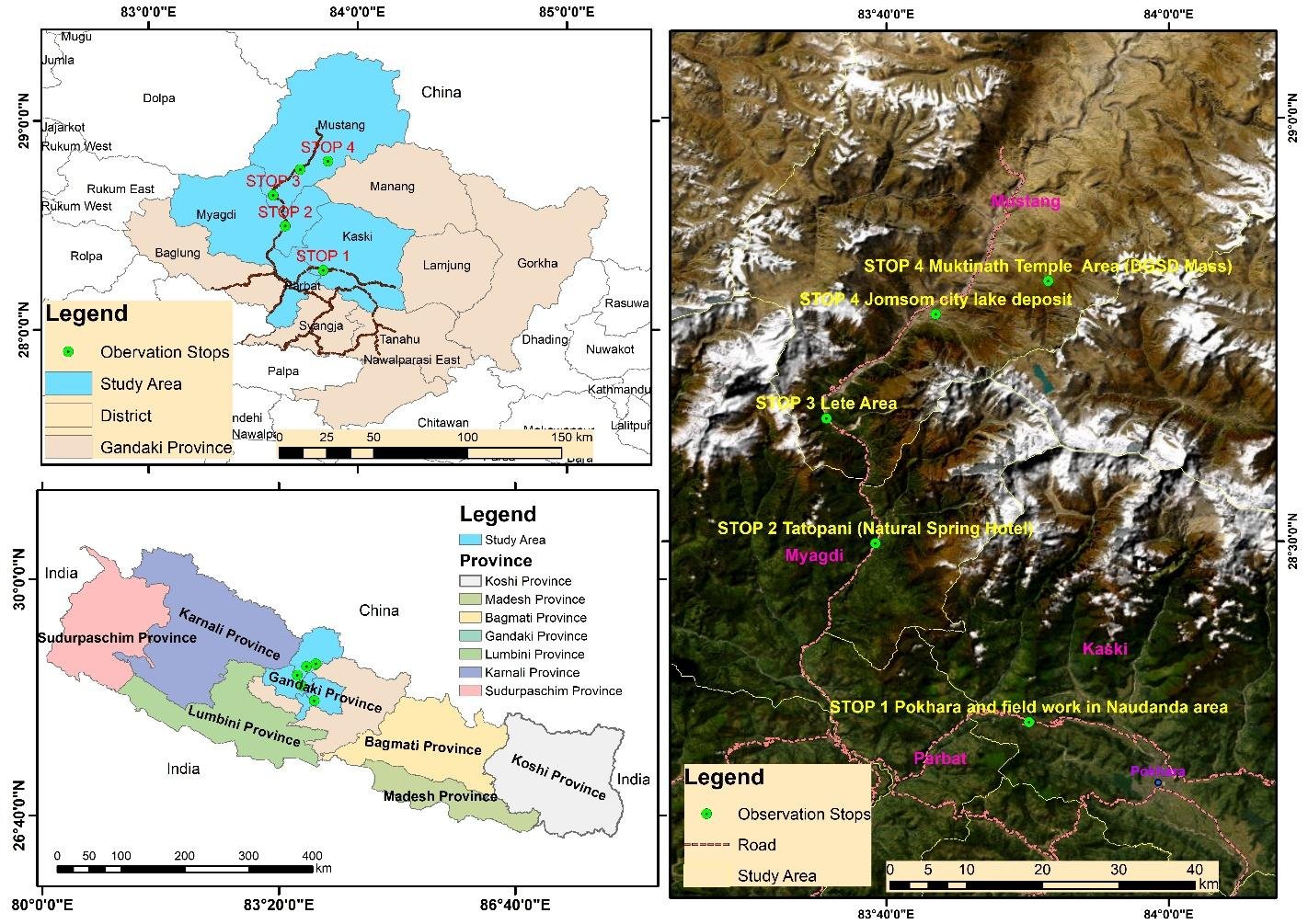
Schedule (tentative)
Stop 1, days 1–4
Pokhara & Naudanda
Mapping a large, deep-seated creeping landslide that affects a village and the local road network, with emphasis on hazard assessment and mitigation.
Base: Pokhara · 4 nights
| Day 1 | Arrival in Pokhara. Arrive by the evening, hotel check-in and an informal welcome. |
| Day 2 | Orientation and local context. Morning introductory session and safety briefing: Nepali history, culture and survival Nepali; Himalayan communities; geology of Nepal and the Himalaya. Afternoon sightseeing in Pokhara. Evening briefing on Pokhara geology and the Naudanda landslide. |
| Day 3 | Naudanda fieldwork. Full day of geological fieldwork and mapping. Evening debrief on observations and preliminary interpretations. |
| Day 4 | Naudanda fieldwork and reporting. Full day in the field. Evening presentation of mapping results and a short technical report. |
Stop 2, days 5–6
Tatopani
An introduction to the regional geology, environmental setting and natural hazards of the middle Kali Gandaki valley.
Base: Tatopani · 1 night
| Day 5 | Transfer to Tatopani and fieldwork. Briefing on the middle Kali Gandaki valley, lunch and a half day of fieldwork. Evening debrief and a session on natural hazards and major engineering geology projects in the region. |
| Day 6 | Fieldwork until noon, then transfer to Lete. Short technical report on the Tatopani area. Evening briefing in Lete on the valley’s geology and hazards in more detail. |
Stop 3, days 6–8
Lete, middle Kali Gandaki
Huge-volume diamictons and diamictites of landslide (rock avalanche, debris flow) and glacial origin: how to tell them apart, and their implications for land instability, fluvial erosion and sediment transport.
Base: Lete · 3 nights
| Day 7 | Lete fieldwork. Full day of fieldwork with lunch in the field. Evening debrief. |
| Day 8 | Lete fieldwork and reporting. Full day in the field. Evening presentation of results and a short technical report. |
Stop 4, days 9–12
Jomsom, Jharkot & Muktinath
Large deep-seated landslides, slope deformations, glacial deposits and landforms, landslide dams and their lake deposits, and striking structures along the river and road cuts.
Base: Jomsom
| Day 9 | Transfer to Jomsom, gateway to Mustang. Road geology and viewpoint stops on the way. Evening briefing on the geology of Mustang and the Jomsom–Muktinath fieldwork. |
| Day 10 | Fieldwork, Muktinath–Jharkot area. Full day of fieldwork. Evening debrief. |
| Day 11 | Fieldwork and reporting. Full day in the field. Evening presentation of Jomsom–Muktinath results and a short technical report. |
| Day 12 | Muktinath temples and return to Pokhara. Visit the Muktinath temples, lunch in Kagbeni, then the bus back to Pokhara. |
Days 13–14
Closing in Pokhara
Closing ceremony and departure.
| Day 13 | Closing ceremony. Diploma certificates and a feedback questionnaire, then lunch. Afternoon: return to Kathmandu by plane or bus, or free time in Pokhara. |
| Day 14 | Departure or optional travel. Morning return to Kathmandu by plane or tourist bus, provided by NSEG. You may extend your stay for trekking or travel in Pokhara, Chitwan or Kathmandu. |
The programme is tentative and may be adjusted for weather, road conditions and safety.
Safety
You should be in good physical condition and aware of the risks of high-altitude environments, including altitude sickness. The final days reach the Muktinath area at roughly 3,700 m.
Provided by the School
- Hard hats and high-visibility jackets
- Basic field equipment and first aid
- Comprehensive safety guidelines
You bring
- Personal travel and health insurance
- Field gear for mountain terrain
- Clothing for variable weather